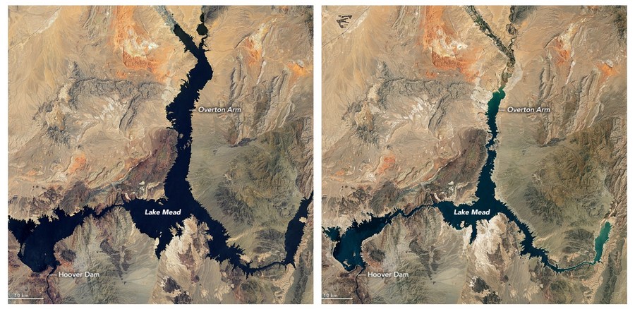
Combo photo taken by NASA satellites shows the water level change between July 6, 2000 (L) and July 3, 2022 in Lake Mead, Nevada, the United States. (Photo credit: NASA Earth Observatory)
Pictures taken from far above the planet show drastic water level drops in Lake Mead and Lake Powell and the tell-tale "bathtub rings" on canyon walls, which illustrate that water levels were dozens feet higher in just the past few years. The Colorado River system is down to 34 percent capacity, another drop from its 40 percent capacity last year.
DENVER, the United States, Aug. 22 -- The record drought in America's Southwest can be seen from 35,000 kilometers above Earth.
Recently released surveillance from the National Aeronautical and Space Administration (NASA) showed areas where the historic "mega-drought" has left gigantic "bathtub rings" on the country's largest reservoirs and vast, parched areas, which now can be seen from outer space.
Federal officials announced new water cuts to states that rely on the Colorado River in a suite of emergency moves to reinforce reservoirs that have hit record-low levels due to climate change and decades of drought.
"In order to avoid a catastrophic collapse of the Colorado River System and a future of uncertainty and conflict, water use in the Basin must be reduced," said Tanya Trujillo, assistant secretary for water and science at the Department of the Interior, in a statement last Tuesday.
According to the latest plan, Arizona and Nevada would lose 21 percent and 8 percent respectively of their annual allotment of Colorado River water. Mexico, which also receives water from the river, will see its annual allotment reduced by 7 percent.
Earlier this summer, the federal government gave the states two months to figure out how to stop using 2 to 4 million acre-feet of Colorado River water to help prop up the reservoirs -- or face the prospect that the federal government would step in and make the cuts itself.
However, water managers in Arizona, California and Nevada last week failed to agree on a plan to cut water in the lower basin after weeks of heated negotiations.
The graphic images underscore the dire threat to some 40 million Americans in seven western states that an anticipated water shortage will create, and were released last week by NASA.com from its satellites that circumnavigate the globe from 35,000 kilometers high.
"NASA satellites have been monitoring waterways in the West for years and documenting how the region is drying up," Vox.com reported Friday.